

August 13, 2024
3 Time required to read
Will this storm become a hurricane? Meteorologists predict
New technology is helping forecasters spot storms that have the potential to become dangerous hurricanes sooner than ever before.
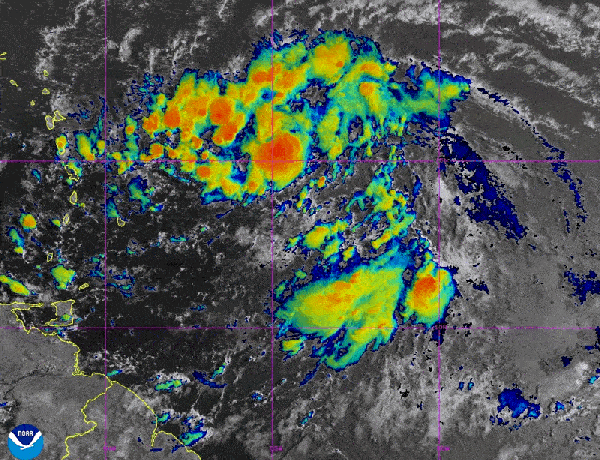
On August 12, 2024, forecasters were watching for signs that potential Tropical Depression No. 5 could develop into a hurricane. It became Tropical Storm Ernesto later that day and was predicted to become a hurricane later in the week.
NOAA/NESDIS/STAR – GOES-East
The following essay is ![]() The Conversation is an online publication covering the latest research.
The Conversation is an online publication covering the latest research.
When tropical meteorologists look at satellite imagery, they often see subtle cloud patterns that hint at something more sinister happening.
The first signs of a potential hurricane can be detected several days before a storm gathers force: thin cirrus outward spreading clouds, the appearance of curving bands of low clouds, and a drop in air pressure are all telltale signs of a developing hurricane.
Supporting science journalism
If you enjoyed this article, please support our award-winning journalism. Subscribe. By purchasing a subscription, you help ensure a future of influential stories about the discoveries and ideas shaping the world today.
These early clues are crucial in predicting the development of events that can develop into devastating hurricanes.
I’m a professor of meteorology at Pennsylvania State University, and my research group uses satellites and computer models to improve forecasts of tropical weather systems. With 2024 expected to be an especially intense Atlantic storm season, it’s more important than ever to detect these early signals and provide early warnings. Here’s what forecasters will be looking at:
Favourable conditions for hurricane development
Hurricanes usually begin in the atmosphere as tropical waves, areas of low pressure carrying a cluster of thunderstorms. As these tropical waves move westward across tropical oceans, some of them can develop into hurricanes.
The formation of a hurricane depends on several specific conditions.
Distance from the equator: Tropical cyclones usually form at least 5 degrees away from the equator because the Coriolis force, which is essential for the initial rotation of low-pressure systems, is weaker near the equator. The Coriolis force is generated by the Earth’s rotation and causes moving air to spin and swirl.
Warm Sea Surface Temperatures: For a hurricane to form, ocean surface temperatures must be at least 26.5 degrees Celsius (about 80 degrees Fahrenheit). Storms absorb heat and moisture from the ocean, and the warm water provides the energy that powers the storm.
Atmospheric instability and moisture: For a tropical cyclone to develop, the atmosphere must be unstable, meaning that warm surface air rises and, because it remains warmer than the surrounding air, continues to rise and thunderstorms develop. There must also be sufficient moisture, as dry air can cause clouds to evaporate and weaken the upward motion within the thunderstorm. These factors are essential for the development of concentrated thunderstorms within a tropical wave.
Low vertical wind shear: Strong vertical wind shear can cause developing hurricanes to split up – the change in wind direction and speed with height – preventing storms from forming and growing and making it harder for hurricanes to keep their vortex aligned.
Early predictions require more than satellites
Recognizing the early stages of a hurricane’s life cycle has been extremely difficult due to the lack of numerous ground-based observatories and weather balloons to provide detailed atmospheric information over the open ocean.
When a storm starts to form, the National Oceanic and Atmospheric Administration’s Hurricane Hunter planes often fly through the storm to take measurements and drop sensors to get more data, but that’s not possible for all thin clouds, especially if the developing clouds are far from the coast.
One of the primary tools meteorologists currently use to predict the early development of hurricanes is satellite imagery, which provides real-time data on cloud patterns, sea surface temperatures, and other atmospheric conditions. For example, GOES satellites operated by NOAA help meteorologists track the development of hurricanes with unprecedented clarity. These satellites can take images at multiple wavelengths, allowing forecasters to analyze different aspects of a storm, including cloud formation, precipitation, and lightning activity.
But satellite observations alone don’t provide enough information for meteorologists to know which tropical waves have the potential to develop into hurricanes.
To improve forecast accuracy, our research group has developed a way to incorporate real-time satellite data, such as humidity levels and cloud patterns, into computer forecast models. This process, called data assimilation, allows for a more accurate and consistent depiction of atmospheric conditions. As a result, forecasters benefit from significantly enhanced predictive capabilities, especially when predicting the formation and progression of hurricanes.
We are currently working with NOAA to refine these technologies and make them more widely available for improved hurricane forecasts and early warnings, giving the public more time to prepare.
As people across North America and the Caribbean prepare for what is predicted to be a particularly intense hurricane season in 2024, the need for accurate, early storm forecasts has never been greater.
This article was originally published on conversation.Please read Original article.