September 9, 2024
4 Time required to read
How wildfires bring rain and change the weather
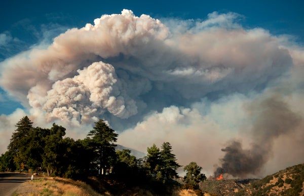
Wildfires create their own wind patterns, and therefore can create their own weather. Here’s how it works:

Pyrocumulus ash smoke towers into the sky as the Apple Fire rages near Banning, California on August 1, 2020.
Josh Edelson/AFP via Getty Images
The following essay is ![]() The Conversation is an online publication covering the latest research.Wildfire explosions, fire whirls, and massive thunderstorms: When fires get big and hot, they can actually create their own weather.
The Conversation is an online publication covering the latest research.Wildfire explosions, fire whirls, and massive thunderstorms: When fires get big and hot, they can actually create their own weather.
In these extreme fire conditions, the usual methods firefighters use to directly control the fire don’t work, and wildfires spiral out of control.
But how does fire create weather?
Supporting science journalism
If you enjoyed this article, please support our award-winning journalism. Subscribe. By purchasing a subscription, you help ensure a future of influential stories about the discoveries and ideas shaping the world today.
I’m a meteorologist and I use data collected from satellites in my weather forecast models to better predict extreme fire weather events. Satellite data shows that fire-induced thunderstorms are happening more frequently than anyone would have thought possible just a few years ago. Here’s what’s happening.
The relationship between wildfires and weather
Imagine a wilderness with dry grass, shrubs, and trees. A lightning strike or a tree branch hitting a power line creates a spark. If the weather is hot, dry, and windy, that spark can quickly start a wildfire.
When plants burn, they give off a lot of heat. This heats the air near the ground, causing it to rise like a hot air balloon because hot air is less dense than cold air. The cold air then flows in to fill the void left by the rising air.
Wildfires thus create their own unique wind patterns.
What happens next depends on the stability of the atmosphere. As air temperature drops rapidly with altitude above the ground, the rising air is always warmer than its surroundings and will continue to rise. If it rises high enough, moisture will condense and form a cloud called a pyrocumulus or flammagenitas.
As the air continues to rise, at some point the condensed moisture will freeze.
When a cloud contains both liquid and frozen water particles, collisions between these particles separate their electric charges, and when the accumulated charge becomes large enough, an electrical discharge (better known as lightning) occurs to neutralize the charge.
Whether a fire-generated cloud develops into a thunderstorm depends on three key factors: the source of the updraft, instability, and moisture.
Dry Thunder
Wildfire environments usually have limited moisture, and dry conditions in the lower atmosphere can result in what’s called dry lightning.
No one who lives in a wildfire-prone environment wants to see dry lightning. Dry lightning occurs when a thunderstorm produces lightning, but the precipitation evaporates before it reaches the ground, meaning there’s no rain to help extinguish the fires started by the lightning.
Fire Whirlpool
As air rises through the atmosphere, it can change speed and direction. This condition is called wind shear. This causes the air to rotate. As the air rises, it tilts its rotation vertically, creating a tornado-like condition.
These fire tornadoes can be accompanied by powerful winds that can spread burning ash and start new fire areas, but are not usually true tornadoes because they are not accompanied by rotating thunderstorms.
The waning storm
Eventually, the thunderstorms fueled by wildfires begin to subside and what rose will subside. The downdrafts from the weakening thunderstorms create erratic winds at the ground that can further spread the fire in directions that are hard to predict.
When fires create their own weather, their behavior becomes more unpredictable and erratic, which only increases the threat to residents and firefighters battling the fires. Predicting changes in fire behavior is critical to everyone’s safety.
Satellite images show fire weather events are not all that uncommon
Meteorologists have known since the late 1990s that fires could cause thunderstorms, but it wasn’t until the launch of the GOES-R series of satellites in 2017 that scientists had the high-resolution imagery they needed to confirm that fire-induced weather is, in fact, common.
Now, these satellites can alert firefighters to new blazes even before a call is made to 911. This is important because wildfires across the United States are on the rise in number, size and frequency.
Climate change and increasing fire risk
North America is at increased risk of heat waves and droughts, with dry land and forests becoming more flammable more frequently as the planet warms, and climate model experiments predict that this risk will continue to increase as a result of human-induced climate change.
As the climate warms and more people move into fire-prone areas, the risk of fires also increases. Fires come with cascading hazards that can continue long after the fire is out. For example, burnt land is more susceptible to landslides and debris flows that can affect water quality and ecosystems.
Communities can reduce their vulnerability to fire damage by building defensible spaces and firebreaks, reducing the vulnerability of their homes and property. Firefighters can also reduce surrounding fuel loads by planning fires.
It is important to remember that fire is a natural part of the Earth system, and as fire scientist Stephen J. Pyne writes, we humans must re-establish our relationship with fire and learn to live with it.
This article was originally published on conversation.Please read Original article.

