


It can get lonely on Mars. NASA’s four-wheeled robot has been roaming the Red Planet for more than three years, navigating the harsh terrain on its own. Losing a fellow IngenuityBut the Mars rover probably found a way to contact us from 140 million miles away, because we all love a good old-fashioned penis joke.
The Perseverance rover recently took an unfortunate shortcut on Mars, whose path traced the outline of a giant Martian sausage. release An image of an ancient river map on Mars overlaid with the path traveled by the robot between January 21 and June 11. The result is a giant penis drawn in the Martian sand. Is this a happy coincidence or a stroke of trust-building genius? You decide.
Giant Martian penises aside, on June 9, NASA’s Mars rover arrived on the planet to search for evidence of carbonate and olivine deposits along the inside rim of Jezero Crater, in a region nicknamed Bright Angel. According to NASA, the area is characterized by outcrops of light-colored rocks likely exposed by river erosion and sediments that filled waterways.
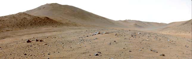
Perseverance had difficulty reaching Bright Angel due to the rough terrain. “We began following the strait in late January and were making fairly good progress, but then the boulders got bigger and more numerous,” Evan Glaser, Perseverance’s deputy strategic route planner lead, said in a statement. “We went from an average progress of over 100 meters per Martian day to just a few tens of meters. It was frustrating.”
As Perseverance encountered more and more boulders along the way, the rover’s automated navigation system (AutoNav) frequently stopped because it didn’t like the route, but the mission’s navigation team found a shortcut through an ancient river channel.
“As we traveled, we kept an eye on the river channel to the north, hoping to find a spot where the dunes were small and far enough apart for the rover to pass through, as they have been known to engulf Mars rovers,” Glaser said. “Perseverance also needed an access road to safely descend. The images showed both, so we made a beeline for it.”
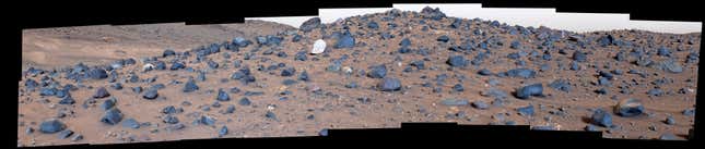
The rover traveled 656 feet (200 meters) in one sol (Martian day), reaching a hill covered in intriguing rocks never before observed on Mars. “The diversity of texture and composition at Mount Washburn was an exciting discovery for the team, as these rocks represent a jumble of geological gifts delivered from the crater rim and possibly beyond,” Brad Gerchinski of Western Washington University in Bellingham, co-leader of the current science campaign, said in a statement.
After leaving Mount Washburn, Perseverance traveled 433 feet (132 meters) north to explore the geology of another part of Mars, nicknamed Tuff Cliffs, before beginning the four-sol, 1,985-foot (605-meter) journey to Bright Angel. And we’re just so happy the rover not only made it to its destination, but had some fun along the way. Cheeky bastard.
Want to know more about space flight? X Gizmodo’s exclusive bookmark Space Flight Page.